Technology and Products
Sensors
All our sensors share a product design approach based on robustness, simplicity, autonomy, and versatility.
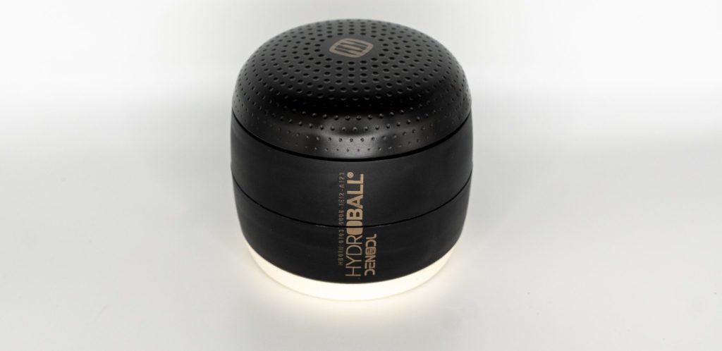
HYDROBALL® is the first of a new generation of soil sensors designed for application in agriculture and professional landscaping, offering an unprecedented level of soil insight relative to its investment cost.
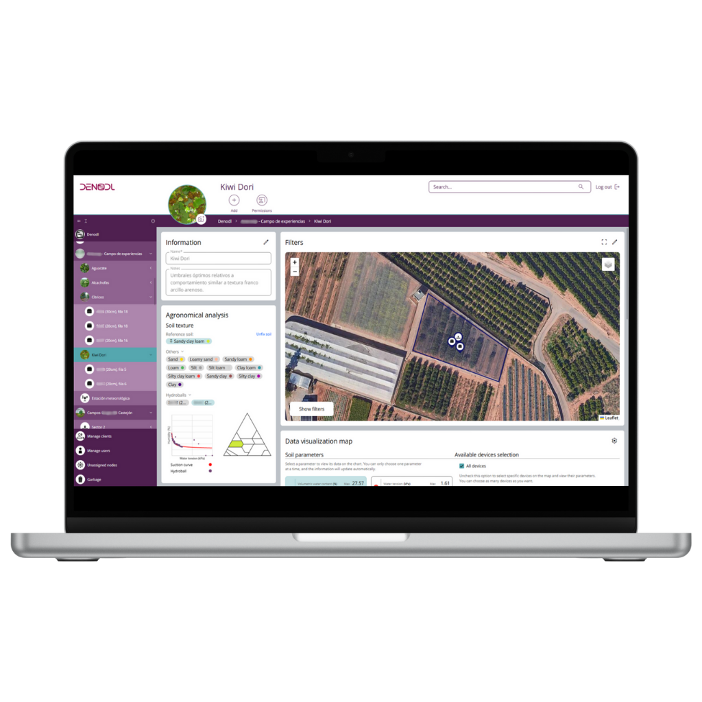
Specializing in the measurement of soil water parameters, HYDROBALL® is the first sensor capable of integrating multiple key metrics into a single device: volumetric water content (VWC), water potential, electrical conductivity, and temperature. This combination allows for highly accurate diagnostics of soil water status and characteristics, including texture classification (according to USDA standards) and water retention curves, facilitating the implementation of precision agriculture techniques. It helps optimize water and input management while improving both crop quality and productivity.
HYDROBALL® is buried at root level and operates autonomously, without the need for cables, data loggers, external power sources, or additional infrastructure. It runs on four AA batteries, offering a battery life of up to four years.
HYDROBALL® transmits data to DENODL® App using two alternative communication protocols: NB-IoT via the cellular network or LoRaWAN®, using a gateway device that collects and sends information to the cloud.
HYDROBALL® is ideal for various applications, including agriculture, professional gardening, sports field management, smart cities, compost monitoring and environmental monitoring, among other uses.
HYDROBALL® Twin has been designed to meet the specific needs of orchard and perennial crop producers, providing an optimal solution for soil water status monitoring at greater depths.
This device shares HYDROBALL®’s measurement, processing, and wireless data transmission technology but is distributed across two interconnected modules positioned at different depths—two twin HYDROBALL® units.
The upper module, responsible for control, data transmission, and power supply, can be placed above the soil surface, optimizing connectivity in any environment. The lower module, buried at the required depth, houses the sensors responsible for measuring four key parameters: volumetric water content, water potential, electrical conductivity, and soil temperature.
By positioning the communication module on the surface, the device ensures maximum connectivity, even in areas with weak signal conditions. This design also simplifies battery replacement without needing to extract the probe. Meanwhile, the measurement module can be installed at depths exceeding 1 meter, allowing for precise monitoring at any point within or below the root zone’s working profile.
HYDROBALL® Twin will be available in August 2025.
HYDROSTICK® is a sensor developed under the LIFE program of the European Commission. It is a modular, multi-level, stick-shaped sensor that can be configured for various applications.
The device consists of an upper module for control, data transmission, and power supply. Three sensor modules, which can be combined as needed, allowing measurements at different depths, with a maximum reach of 1.20 meters.
HYDROSTICK® Sensor Groups:
- Group 1: Measures volumetric water content, water potential, electrical conductivity, and temperature. Enables soil suction curve analysis and texture classification based on USDA standards.
- Group 2: Measures volumetric water content, four-wire electrical conductivity, total salt content, and temperature.
HYDROSTICK® will be available in January 2027.
DENODL® APP

DENODL® App is a SaaS platform for data visualization and management, enabling the creation of a digital twin for agricultural operations, smart cities, parks and gardens, golf courses, and other sectors. It provides detailed mapping of facilities, including irrigation zones, green areas, and sensor locations, all within an intuitive and user-friendly interface.
The platform stores and displays historical and real-time data from sensors, integrating additional data layers such as weather forecasts and allowing users to compare and combine metrics from different sensors. Data can also be exported for external analysis.
Key Features
- Customizable metric ranges, allowing users to set thresholds for key parameters.
- Push notification alerts when values exceed predefined limits.
- Data analysis, delivering real-time insights into soil conditions, including the dynamic construction of soil characteristic curves, precise texture classification, and key moisture thresholds such as saturation point, field capacity, and wilting point.
- Unlimited user management and permissions control.
- Access to DENODL® App is free with the purchase of any DENODL® device.

ADVANCED ANALYTICS / IA
DENODL® has developed an automated data analysis system that delivers high-value insights to users across multiple sectors. This system generates automated reports that provide clear, precise, and actionable recommendations based on real-time data. By integrating sensor data, plant information, weather forecasts, remote sensing, and other critical factors, the system offers tailored analysis for crop management, green spaces, and composting. It allows users to make informed decisions with confidence, eliminating the need to spend hours analyzing complex data and graphs. This breakthrough removes barriers related to the complexity of data interpretation, ensuring effortless access to key insights. The reports include: potential growth analysis, disease forecasting and early detection, actionable recommendations, such as optimized irrigation strategies.
The reports are customized for different sectors, analyzing key parameters relevant to each use case, ensuring users receive the most relevant information for their specific needs:
- Agricultural management reports (horticulture, cereals, perennial crops).
- Golf course turf management reports.
- Irrigation management reports for public and private parks and gardens.
- Sports field management reports (e.g., soccer fields).
- Composting process management reports.
Advanced prescriptive reports with data analytics will be available in mid-2025.
By correlating real-time sensor data—such as soil moisture and temperature trends—with additional information layers, including crop-specific data, DENODL® provides a predictive analysis for the early detection of diseases. This system anticipates the risk of fungal infections, bacterial diseases, nematodes, and pest infestations that could threaten crops and turf.
Our advanced analysis identifies sector-specific risks, studying the most common diseases for each crop species and variety. This enables users to proactively prevent outbreaks and implement preventive measures, ultimately enhancing plant health, quality, and productivity.
Early disease alerts will be available by mid-2025.
Our platform allows for the integration of satellite monitoring to enhance crop management, combining satellite imagery and climate prediction models with real-time data from our sensors.
Through this advanced analysis, users can assess soil moisture levels with greater accuracy; identify plant stress areas before visible symptoms appear; detect diseases at an early stage for proactive intervention; calculate key indices, such as NDVI (Normalized Difference Vegetation Index), to visually monitor crop vigor; map terrain variability to improve irrigation planning and input application, ensuring more efficient and sustainable resource management.
By combining satellite monitoring with real-time sensor data, DENODL® provides a broader and more precise understanding of crop conditions. This synergy enhances prescriptive reports, enabling data-driven decisions for optimized irrigation, fertilization, and plant health management, ultimately improving yield and efficiency.
Satellite monitoring functionality will be available by mid-2025.
Our cloud-based platform features an open architecture, allowing seamless integration and operation with third-party systems via APIs. This enables smart irrigation management, automatically adjusting timing and water volumes based on real-time soil and crop needs detected by the sensors.
From a single platform, users can: Monitor irrigation status in real time, remotely schedule irrigation based on specific requirements, fully automate irrigation for optimized water usage and efficiency.
Automation functionality will be available in early 2026.